
|
This article originally appeared in Geospatial Solutions Magazine's Net Results column of June 1, 2003. Other Net Results articles about the role of emerging technologies in the exchange of spatial information are also online. |
| 1. Introduction and Glossary 2. Who's Zoomin' Who? 3. Public Science 4. Cast of Thousands | |
| Who's Zoomin' Who? At first blush, the City of San Francisco’s public geospatial Web site, SFProspector, looks like a typical (if particularly clean and sophisticated) interactive spatial Web site for assessor parcel maps and demographic data. Unlike many such sites, however, SFProspector is not just a data viewer. Erich Seamon, chief of the city’s enterprise GIS (www.sfgov.org/gis), collaborated with the Mayor’s Office of Business and Economic Development during the planning phase of the project, and consequently envisioned a site that would both support and catalyze local commercial economic development. As a result, not only do SFProspector’s maps show parcel boundaries and their associated attributes, but the interface helps visitors evaluate any property as a potential new office or store location. From a radius around a selected parcel, SFProspector summarizes demographics and identifies existing businesses, both on the map and by market (see Figure 1). If an area seems viable for new business, the next step is finding property to rent or buy. Anticipating this need, SFProspector includes listings — by parcel and with site photos — of available commercial property (see Figure 2). |
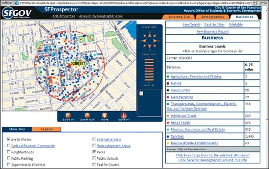
Figure 1: The City of San Francisco’s SFProspector Web site helps businesses find available commercial properties and evaluate existing business demographics. |
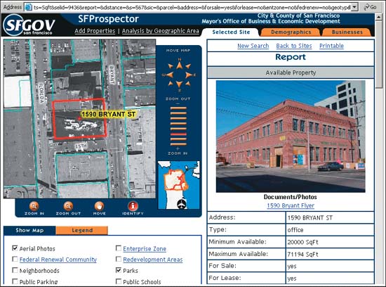
Figure 2: Realtors use a private, Web-based interface to upload real estate listings and property photos to SFProspector for immediate viewing by potential customers. |
| As with most assessor’s mapping sites, the parcel boundary and attribute
data are owned and maintained by the County of San Francisco.
The real estate listings, however, are maintained by private teams of real
estate brokers in various local offices. SFProspector includes data about
property availability and pricing as well as site photos because a small
cadre of realtors enter the data themselves. This collaboration between private
and public entities is what sets SFProspector apart from the typical municipal Web
site. Devoid of formal GIS training, the realtors are connected to the city’s enterprise
GIS information only by shared geography, a mutual desire to stimulate
local commercial business, and a Web browser. In the six months since the launch in November 2002, 15 commercial real estate companies have registered to update the SFProspector site, uploading approximately 600 photos of rental and sale properties. Logins are individual by broker with one superbroker for each company. Typically, the superbroker logs in first, creates an entry for an available property, and tags it with a broker’s name. Individual brokers later add some photos and make changes to their listings as needed. Behind the map. Usability and education are critical components to a collaborative spatial Web site. At SFProspector, an administrative data entry dashboard (unavailable to the general public) helps the realtors keep track of their holdings. When a superbroker logs in, she can see all subbrokers and their information, such as how many sites have been posted and their posting dates. The dashboard is one of several efforts to educate the (nontechnical) brokers in data-entry techniques, an effort that began in person. As part of the overall site and administrative dashboard design process, the prime consultant, GIS Planning (www.gisplanning.com), joined city staff in holding training sessions at individual real estate companies. GIS Planning also educated the city’s technicians. Six months after signing the contract to build SFProspector, GIS Planning passed site-management control to the city staff. Seamon emphasized that the city didn’t try to build their own application interface, but instead injected their requirements into GIS Planning’s best-of-breed solution. Even with training and a usable dashboard interface, nontechnical realtors sometimes still need help with data entry. Rather than give them a direct line to the site’s developers, the Mayor’s Office of Economic Development handles basic training aspects of incoming support calls, only passing true technical problems to the technical team. Realtors communicate mainly via e-mail, but can also phone for support. Carrot and stick. The realtors got a message from the top that SFProspector was important. Mayor Willie L. Brown held a session for real estate executives in the City Hall press room in which he clearly articulated his executive sponsorship for SFProspector to the private sector. According to Seamon, “Executives, politicians, and bureaucrats are starting to see that technology has a direct relationship in affecting the economy,” and this session formalized the intent to collaborate for mutual gain. What are the gains, specifically? The benefit to real estate executives is increased exposure; the city’s Web site serves 1.5 million visitors per month. The benefit to the city is increased commercial activity and the resulting tax revenue. The benefit to IT bureaucrats and the public they serve is a more tightly integrated information source. During the design phase, the site’s planners also evaluated the competition, namely, private commercial applications such as Costar (www.costar.com) whose model (that is, exposure increases sales) overlapped the city’s. However, the city’s control of business data and ability to offer their service freely set their model apart. Lessons learned. Seamon said managing construction of SFProspector was allconsuming for four of the 12 months, but not for technical reasons. “The technical piece is the easiest to deal with; up-front time with the vendor and existing staff with experience in the map services arena allowed for a smooth technical implementation,” Seamon said. “That said, you can develop the greatest application, but if nobody’s using it, it has no power or value. The budgetary, organizational, and media pieces, such as communicating the value to other organizations, were much more challenging. Realtor involvement was critical, so we spent a lot of time reinforcing the interactive value to these organizations,” he continued. The technical ease Seamon describes was also due to the fact that the city’s underlying enterprise GIS was in good shape, with clean data and spatial technology already in place. (SFProspector runs on IBM (www.ibm.com) hardware and IBM’s DB2 database connected to ESRI’s (www.esri.com) ArcIMS with ArcSDE middleware, all part of internal GIS operations before the SFProspector project began.) The city departments supplying data were unified and there was no need for additional server or software purchase — the primary expense was paying the vendor. Seamon considers this project an example of rapid application development (the site was up in six months) due to pre-existing enterprise GIS investment. |
| 1. Introduction and Glossary 2. Who's Zoomin' Who? 3. Public Science 4. Cast of Thousands |
|
|