|
Directions and Maps from Berkeley, San Francisco, and Local Airports to the Wedding and the Rehearsal Dinner |
|
|
|
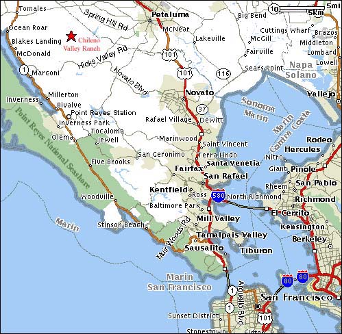
For General Reference: Northern San Francisco Bay Area and Marin
County Map The wedding site is marked with a red star (upper left). San Francisco and Berkeley in the lower right. (Both airports are a little further South of this map.) |
|
|
|
|
Driving directions from Oakland Airport and Berkeley to the
wedding site |
. . . . |
Driving directions from San Francisco Airport and City of S.F.
to the wedding site |
| Distance from
Oakland Airport: 62 miles. Driving time without traffic: 1 hour, 25 minutes. Leave the Oakland Airport on Airport Drive (1.2 miles). Turn right onto Hegenberger Drive and follow it 0.8 miles to the Route I-880 freeway. Merge onto I-880 heading North towards Downtown Oakland. Stay on I-880 North for 10.5 miles. Shortly after passing the University Avenue exit (Berkeley), I-880 becomes I-80 and I-580. Merge to the right, taking I-580, the more narrow of the two splits, toward Point Richmond/San Rafael. Ten miles past this split, you will pay a $2 toll to cross the Richmond bridge. Cross the Richmond bridge. After the bridge, I-580 merges with US Route 101 North. Stay on Route 101 North for 20 miles until you reach the Petaluma Blvd Exit. Follow the illustrated directions below to find the wedding site from the Petaluma Blvd Exit. |
. . . . . . . . . . . . . . . . . . . . . . . . . |
Distance from the San Francisco Int'l Airport: 62 miles. Driving time without traffic: 1 hour, 30 minutes. From the San Francisco Airport, merge onto US Route 101 North toward San Francisco. 1.1 miles later, merge onto I-380 West toward I-280/San Bruno. Two miles later, merge onto I-280 North toward San Francisco. Six miles later, take CA-1 North toward 19th Avenue/Golden Gate Bridge. In 7.2 miles, take the exit on the left toward the Golden Gate Bridge. Cross the Golden Gate Bridge--you will now be on US Route 101 North. Stay on Route 101 North until you reach the Petaluma Blvd Exit, 31 miles from the end of the Golden Gate Bridge. Follow the illustrated directions below to find the wedding site from the Petaluma Blvd Exit. |
|
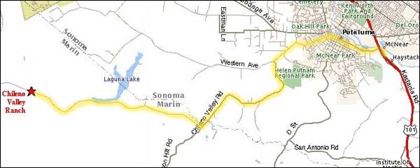
Getting to the Wedding site from Route 101 via the Petaluma Blvd Exit This map and the illustrated directions below show how to find the wedding site (marked with a red star at far middle left). The route traced in yellow follows Petaluma Blvd to Western Avenue to Chileno Valley Road, then right to remain on Chileno Valley Road at the intersection with Wilson Hill Road. |
|
|
|
| Illustrated directions from Route 101 Petaluma Blvd Exit to the wedding site | ||
 |
 |
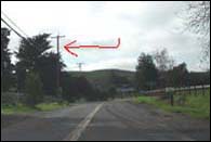 |
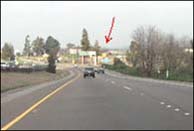
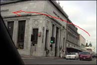
| 1. From Highway 101 North, take the Petaluma Blvd. Exit. | 2. Head South through town. In downtown Petaluma, turn LEFTon Western Avenue (at the Antiques Store that looks like a bank). | 3. Leave Petaluma on Western Avenue. Just after seeing signs for Walker Creek Ranch and Helen Putnam Park, go LEFT at sign for Chileno Valley Road. |
|
|
 |
 |
|
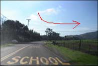
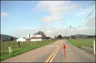
| 4. Follow Chileno Valley Road for 3.8 miles. After crossing two small bridges, look for the "SCHOOL XING" on the asphalt and turn RIGHT onto (another branch of) Chileno Valley Road. | 5. Here's what you'll see after your right turn. You're nearly there. Stay on this road for another 5.3 miles. Drink in the beautiful scenery. Smile. |
|
|
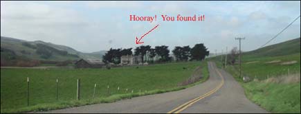 |
| 6. You drove the last 5.3 miles. Time to relax! turn LEFT into Chileno Valley Ranch (#5105), parking in the field opposite the house, behind the line of dark trees. |
|
|
|
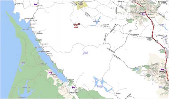
The Wedding Site and surroundings The wedding site is marked with a red star (upper middle). Point Reyes National Seashore and Tomales Bay are to the West (left). Route 101 is the red line (right) connecting Novato (lower right) and Petaluma (upper right). Purple bed symbols mark towns with lodgings. For a larger version of this map, click here or on the map image below. |
|
|
|
| Back to Rachel and Jonathan's Wedding Home Page |
|
|