
|
This article originally appeared in Geospatial Solutions Magazine's Net Results column of May 1, 2003. Other Net Results articles about the role of emerging technologies in the exchange of spatial information are also online. |
| 1. Introduction and Glossary 2. First ruby slippered steps 3. Scarecrow, tinman, lion 4. And Toto, too | |
| Scarecrow, tinman, lion If your desire to create an interactive spatial Web site now teeters in a precarious balance with your limited budget or fear of complexity, don’t despair quite yet. Though you might begin alone on the yellow brick road to a spatial Web site, an eclectic collection of travelers will soon burst from the wilderness to join you. Following that road as an experimental user myself, I found four friendly Web hosts that cater specifically to spatial customers. Each has a different philosophy, business model, and pricing structure, but all are small, responsive, and eager to succeed. If I only had a brain. Some organizations have the data and the application requirements, but lack requisite in-house skills (or possibly budget) to produce a spatial Web site. Latitude Geographics Group, Ltd. (www.latitudegeo.com), a company of 12 full-time spatial gurus for hire in Victoria, B.C., Canada, offers a service called Geocortex Internet Mapping for just this need. Their depth of experience in spatial technology was immediately clear during an interview with Steven Myhill-Jones, Latitude Geographics’ president and CEO. As unassuming as L. Frank Baum’s brainy scarecrow, Myhill-Jones seems in eternal pursuit of the next interesting Internet-enabled capability. (Geocortex’s latest advance, for instance, is browser-based 3-D terrain modeling.) Though "organically driven by customer need," Geocortex’s current customers all use ESRI’s ArcIMS software. Latitude Geographics has grown as an ASP for the past three years by expanding its offering to pivot on services and transferring knowledge to clients. "People are uncomfortable with hosting on an instinctual level," said Myhill-Jones. "Thanks to debacles like WorldCOM, there are concerns with keeping valuable data elsewhere, and trusting entirely in specialists rather than being self-reliant." Furthermore, many of Geocortex’s customers in state and local government have policies forbidding extended use of ASPs. As a result, the Geocortex service has no long-term contract requirements, often hosting only initially, during the development and knowledge transfer phases of spatial Web site projects. In addition to full hosting, customers can also deliver a computer and data to Latitude Geographics for software installation and application development, then collaborate online to develop the site. When the work meets with satisfaction, the customer can migrate their machine in-house, or continue the cohabitation arrangement for a monthly fee. Those comfortable with remote hosting can use Web browsers both to alter the application interface, and even to edit their data online, using Geocortex’s Internet Mapping Framework (IMF) software. Pricing is determined on an ad hoc basis depending on each customer’s unique requirements. Generally, projects range between $300 and $800 per month, with the most popular package costing $495 per month, including 24-7 support. To date, Latitude Geographics has not reported any security breaches. A list of Internet reference sites using the Geocortex service appears at www.geocortex.net/gallery (see Figure 1). |
 Figure 1: The Whistler Corridor Land and Resource Information Server is an example of an online GIS application powered by Geocortex. |
|
If I only had a heart. The sentimental tinman of spatial Web hosting, LMI.net (www.lmi.net), a company of 12 full-time people in Berkeley, California, brings a kinder, gentler approach to technology. In addition to the usual ISP technical offerings, LMI.net focuses heavily on customer satisfaction and affordability (including discounts to local nonprofit organizations). LMI.net is well-suited to Berkeley’s culture, openly encouraging local patrons to "Eschew corporate globalization!" by hosting with a small local provider. Also like most ISPs, the majority of LMI.net’s customers are small- and medium-sized businesses with nonspatial Web sites. Unlike most ISP’s however, LMI.net offers users secure shell access to their accounts. This means users can write, compile, and run programs, modify their Web sites directly, and, in short, do anything (within the bounds of security) that the UNIX command line allows. For a $50 one-time setup charge and $25 per month hosting fee, customers get 25 MB of storage space and 2 GB per month of data exchange over their high-speed connection. Spatially, LMI.net’s shell access allowed me to install (for free) UMN’s Mapserver in conjunction with a customization module called Perl Mapscript. Not a full-fledged GIS, but adequate and speedy enough for most interactive mapping needs, Mapserver proved itself well at mapping the crime density in (where else?) the City of Berkeley, all with self-digitized or free data (see Figure 2). |
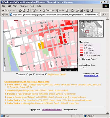 Figure 2: Though spatial websites are not their core business, LMI.net’s hosting architecture is extensible with UMN’s Mapserver and Perl Mapscript, as demonstrated by this City of Berkeley crime mapping application at www.giswebsite.com/cgi-bin/b19.cgi. |
|
Though LMI.net does not intend to be a spatial services provider, they are prepared to assist other spatial developers with the installation of their own Mapserver/Mapscript-enabled account. This provider proves the point that any web host can become a spatial web host if they have the heart to install map server software. If I only had the nerve! Fearful about hanging your valuable data out to dry? Courage! The anything-but-cowardly lion of spatial Web hosting and high-end example in this survey, Metropolis New Media (www.metropolisnewmedia.com), is ready to help. A company of two full-time and three part-time people based in San Jose, California, Metropolis’ number one concern is security. In fact, secure hosting is Metropolis' only concern, as they refer all spatial services requests to their business partners. For $1,000 per month, Metropolis scrubs a system with various OS-level cleansing utilities, installs all required Web and map server software, including ESRI’s ArcIMS, and colocates the system in a high-speed facility (see Figure 3). After that, building the Web site is up to you (or your hired help). |
 Figure 3: Metropolis New Media installs their customers’ systems in this Northern California data center. |
|
To protect their clients’ sites, Metropolis analyzes network traffic for any of the thousands of known attacks (such as spoofed IP headers), drops suspicious traffic in real-time if necessary, and alerts appropriate personnel. Unlike a firewall security system where a port is either open or closed, Metropolis uses "stealth-response" algorithms that analyze and control content in both directions, in and out of the server. For instance, if specified, LizardTech (www.lizardtech.com) MrSID file formats can be loaded into the system, but never output. The company’s co-founder and CEO, David L. Hunsinger, explained that (unlike state and local government clients), entities such as banks may have security policies forbidding the use of Internet services on their network. Consequently, to provide site-selection services to their branches without violating corporate policy, Metroedge, a Chicago-based bank, uses Metropolis as its spatial Web host. Another of Metropolis’ well known customers is David Rumsey, whose public map collection is online at www.davidrumsey.com.
|
| 1. Introduction and Glossary 2. First ruby slippered steps 3. Scarecrow, tinman, lion 4. And Toto, too |
|
|