| This article originally appeared in Geospatial Solutions Magazine's Net Results column of October 1, 2000. Other Net Results articles about the role of emerging technologies in the exchange of spatial information are also online. | |
| 1. Introduction and Glossary 2. Get the Right Shrink 3. Ride the Wave 4. Color Safe or Sophisticated? | |
| Ride the wave Typical spatial Web site designers both desire and fear a sharp rise in traffic to their sites. If only we could be sure that our image-servers would keep pumping out small, compressed, complete images to all comers as the hit rate rises from 100 hits per day to 100 hits per second. Standard image compression techniques only go so far -- even compressing a 50 megabyte image down to 5 megabytes won't make much difference to people using modem connections. Such large images will never arrive soon enough in either original or compressed format. And yet, creation of large tiled image collections is the norm in many aerial surveying operations. How can these large tiles be posted to the Internet quickly, seamlessly, and reliably? Wavelet technology is an important part of the solution. LizardTech offers a popular commercial solution to these related image management and display problems with its MrSID format and wavelet-based compression bundle. MrSID s noteworthy features include high compression ratios, multiple resolutions, selective decompression, and seamless mosaicking and browsing. Wavelet technology differs from the original JPEG strategy in the way it summarizes groups of pixels. One of the original JPEG compression algorithms, discrete cosine transformation, saved groups of eight pixels as individual blocks. Wavelet technology substitutes wavelets for blocks. Without attempting to demystify the mathematics of wavelets, the important point is that they are more compressible than blocks. Actual compression ratios vary from image to image, but LizardTech's benchmarks average 20:1 for grayscale and 50:1 for color images (both subject to user control for the best balance between compression and resulting image quality). By compressing multiple image tiles into a seamless database, MrSID removes multitile management hassles. If a user requests a view that spans multiple tiles, he or she will receive what appears to be just one image. To insure consistently small file transmission sizes at any zoom factor, MrSID stores multiple resolutions of the same image (or built-in metadata instructions for generating small files at any resolution). This image pyramid strategy means that when a user views the air photos for an city, he or she will see a single, fast-displaying, low-resolution view rather than a high-resolution, multimegabyte, multi-tile composite. At regular intervals, MrSID mosaics and resamples pixels to achieve this same effect no matter where a user zooms. In resampling, a group of pixel values are averaged together and stored as a single pixel value. MrSID's selective decompression makes the actual painting of the images on screen faster than conventional viewers because only the viewed portion of any given image tile is decompressed (or cached in memory) before painting. This efficient use of RAM is ideal for sites needing to generate many images per second using limited computing resources. Earth Resource Mapping offers a similar compression technique know as ECW. The compression technology uses a discrete wavelet transform process similar to MrSID to break images into tiles for compression. Unlike MrSID, though, ECW is said to perform discrete wavelet transforms on the entire image using a line-by-line recursive multilevel approach. Interestingly, Earth Resource Mapping and LizardTech are currently in litigation regarding patent infringements between their products. The new JPEG standard, on the other hand, incorporates wavelet-based compression from patented algorithms through a multivendor agreement by DIG participants. Faster still. Even spacesaving techniques, such as LizardTech's MrSID and Earth Resource Mapping's ECW, may not increase image-transmission speed enough for unusually high-traffic sites like Microsoft s Terraserver or the recently launched GlobeXplorer.com. Steady responses to extremely high hit-rates require not only compressed image files, but very fast image servers. GlobeXplorer meets this challenge with a unique combination of technology, business model, and content. Technologically, GlobeXplorer s image-serving system is blisteringly fast because of a Sun Microsystems chip-level process combined with compressed image storage on raw disk. In essence, GlobeXplorer has built its own operating system centered around images that can reproject, resample, and mosaic image tiles, and serve the result as a 25 kilobyte JPEG of any specified extent, all faster than a standard operating system could find and serve an identical, preprocessed JPEG file from conventional disk space. Mosaicking, in this case, means that the best quality images for any requested extent will appear in the final delivered image. If the GlobeXplorer library has a color close-up of your town's football stadium as well as standard black-and-white orthophotos at a larger scale, an image request that included the stadium might return a composite color plus black and white result. As the library grows, its output reflects changes in quality. Members always get the best quality image mosaics. Figure 5 shows how higher-quality images overlay others in one output file for www.nbcolympics.com. |
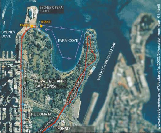 Figure 5: www.nbcolympics.com showcases the use of GlobeXplorer imagery for a triathlon course map. Notice variation in image quality (sharp or blurred) due to mosaicking different sources. |
| GlobeXplorer's image server also combines hardware and software load-balancing. Imagine, for instance, how demand for images in the Florida panhandle might become intense when a hurricane threatened that region. GlobeXplorer's performance detection software checks for signs of image-specific traffic and replicates popular images across an array of disks until the speed returns to normal. According to CEO, Rob Shanks, GlobeXplorer owns the largest online commercial archive of geospatial imagery and is increasing their holdings on an ongoing basis through a content partner program. Partners who deliver their images through GlobeXplorer's system earn royalties on each image served. Part of these royalties pay for new imagery, and the content continues to grow. Although there is public access to some images, the higher quality content is available on a metered subscription basis, either by annual fee or per image served. Given their plans to serve such an extensive library of satellite and orthophoto images the same way MapQuest serves symbolic maps, GlobeXplorer will need this sub-second speed and a flexible business model to respond efficiently to worldwide ad hoc image requests. In fact, GlobeXplorer has partnered with MapQuest to serve maps in conjunction with imagery.
|
| 1. Introduction and Glossary 2. Get the Right Shrink 3. Ride the Wave 4. Color Safe or Sophisticated? |
|
|