In the City of Oakland, consultants and city staff worked together to customize ArcView (with Avenue) and Arc/Info (with AML) so that the tasks for maintaining the most critical and rapidly changing datasets were embedded into the maintenance interface. To get training in the maintenance of any layer, users simply begin using the system and learn as they go.
After working directly with City staff to capture and convert the most critical datasets (streets, parcels, zoning, utilities), consultants customized ArcView and Arc/Info for specific tasks such as zoning updates, parcel subdivisions, and other daily maintenance activities. The customized sessions included step by step, cartoon-like directions permanently displayed during the editing process. The GUI is designed for untrained users so that the maintenance process for critical layers remains intact despite staff turnover.
The customized applications were created using Avenue, AML, ArcView, and Arc/Info. They sometimes rely on client-server sessions between ArcView and Arc/Info, sometimes over a network. The purpose of this paper is to highlight the application and its functions as well as to review the technical challenges encountered during the implementation of a staff-maintained enterprise-wide GIS.
The new goal of the GIS jump-start became not just a working dataset, but a sustainable update process controlled entirely by City staff and requiring no more than one to two hours of training for a person new to GIS. To reach this goal, the instructions for editing each layer were embedded into the graphical user interface used to edit that layer. For instance, if the layer was to be maintained with ArcView, then the instructions for maintaining that layer would be part of a customized ArcView project. To succeed, the instructions could not be part of help screens that were seen only when the users were confused; rather they would be constantly part of the visible project, prompting the user every step of the way.
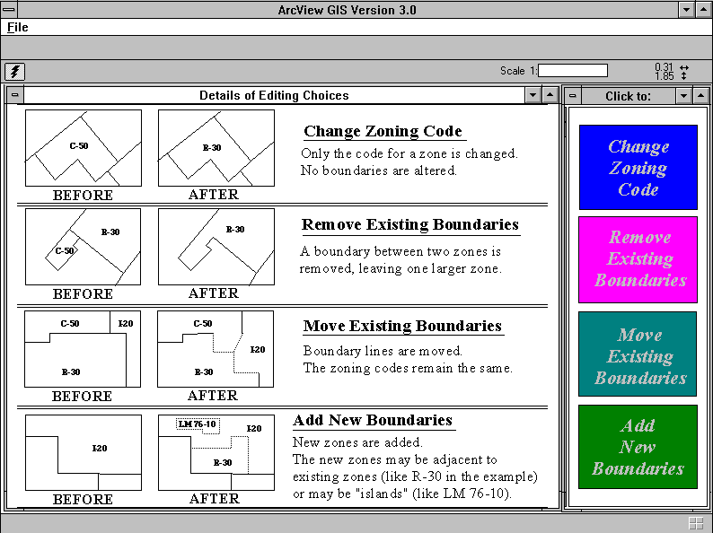
In the case of zoning, the update system has multiple user screens leading the way through any of four different edit routines. Following is the series of steps through the process of maintaining the zoning GIS dataset to document a newly sub-divided zone.
Users opening the ArcView project designed for maintaining the zoning GIS dataset are greeted by the following series of four possible edit routines:
Notice that the four possible edit routines for the zoning layer are described with both words and pictures. Many users prefer a picture or cartoon-like direction rather than a written direction. To the right of the directions are colored polygons. These are features of a polygon shapefile with hotlinks to Avenue scripts that activate other projects.
In this example, the user wants to subdivide one parcel into two parcels, so she clicks the "Add New Boundaries" button. The result is the following screen:
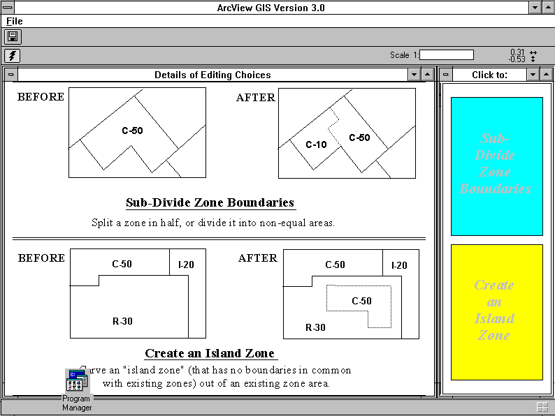
Because the task of adding new boundaries could involve splitting an existing zone or creating an "island" zone within an existing zone, both options are the topic of this user screen. In this example, the user wants to sub-divide zone boundaries, and so clicks the blue box to be taken to the next screen.
The next screen has step-by-step directions for subdividing zones. It looks like the following:
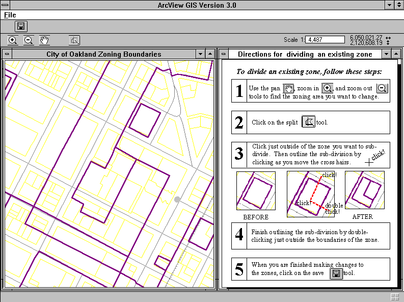
Notice on this screen that the only tools available to the user are the ones described in the directions at the right of the screen. Even tools like the pan tool or zoom tools, which are often assumed to be intuitive, are mentioned in the help screen (although not defined in detail).
Also notice that the tool icons have not been altered from their standard ArcView appearances. If users advance to the full functionality of regular ArcView, they will still recognize the editing tools from these maintenance sessions."
The edit screens are customized such that changes to the data are possible, but changes to the editing screens themselves are not possible without a password. This way, the users can return to the same familiar edit screens every session but see the consequences of their edits.
Further steps in this example would lead the user back to the introductory screen and then through the zone renaming edit steps. In all, there are eleven possible screens for performing edits to the zoning layer. In a typical edit session, most users would only encounter two or three of them. Similar interfaces to the maintenance of GIS datasets are also designed for large, critical coverages such as the Assessor's Parcels and the Center-of-Pavement (streets) datasets. The managers of these datasets are relieved that they do not have to send their staff to long training sessions in order for them to be able to perform a few simple edit routines.
All of these interfaces rely upon Avenue and ArcView with occasional use of interapplication communication with Arc/Info and AML to update changes to a master repository of datasets. For the users, this step is either invisible or a single button click event. For the programmers, the interapplication communication posed the greatest technical challenges.