|
|
| |||||||||||||||||||||||||||||||||
|
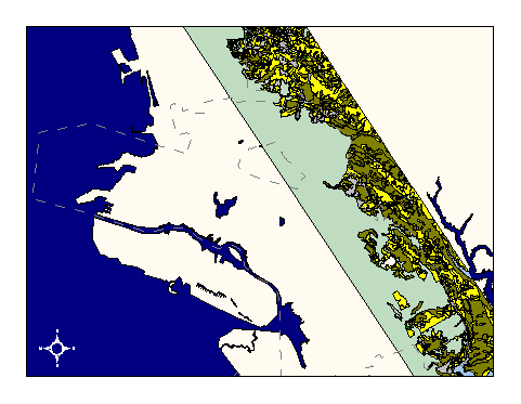
City of Oakland data set: Vegetation class in wild land areas |
|
 |
Who maintains the data for this layer: Prof. John Radke, AEGIS lab Data Maintainer Phone: (510) 643-5995 Who converted the data into a GIS format: Prof. John Radke, AEGIS lab GIS Technician Phone: unlisted Size of GIS layer (KB): 1480 Size of export file (KB): 2086 Where is the layer stored (on the k-drive): k:\gisdata\other\vege.e00 This GIS layer was last updated on: 2/24/97 This metadata was last updated on: 3/20/97 This layer's FGDC category description is: Other (Non-FGDC) |
|
Data Set Description: Vegetation classification of East Bay Hills study area (San Leandro to El Cerrito) including fire-related characteristics of vegetation classes. Non-standard Attributes in table:
Data Source History: The dataset was supplied by AEGIS lab, UC Berkeley, P.I. John Radke. AEGIS's source history is as follows: "...in this research study the vegetation polygons were delineated in five acre or greater management polygons and characterized for their fire fuel potential. Data input--More than thirty stereo pairs of black and white aeial photographs and color aerial photographs were available for the study site. The color aerial photographs were taken by NASA in a C130 flight on August 5, 1993. Polygons for the different vegetation types were delineated on the 1:12,000 photographs using acetate overlays. Minimum size was 5 acres. The vegetation was typed for the polygons using the classification scheme defined for the vegetation used in the fire models. Initially, the photo interpreters were trained using the GPS system for ground visitation and vegetation typing. Only the vegetation within the study site was delineated and typed on the acetates. In addition, the residential vegetation areas contained a wide variety of species and conditions that did not fit into the vegetation classification scheme. These areas were not typed. Data processing--The majority of the polygons were visited on the ground using a Trimble GPS to geo-position the polygons and record the vegetation type, fire model and polygon-ID. When the ground crew determined that the polygon boundaries were not adequately outlined, they made changes and polygon boundaries were redrawn. In some instances polygons were eliminated, new polygons delineated and/or vegetation types corrected. The overall photo interpretation accuracy was determined from the polygons that were first photo interpreted and then ground visited. The delineated polygons were transferred to an acetate overlay that showed the roads and streams. The polygons are only approximately positioned using roads and streams to help locate the polygons. The drawn polygons were subsequently digitized and input to the GIS. The boundaries of the digitized polygons vary with the degree of topographic displacement. Data output--The layer is delivered in Arc/Info format as a coverage containing polygons with vegetation attributes attached. Quality Check: The data was received as an Arc/Info coverage in UTM projection, NAD27. It was converted into Cal Stateplane, NAD83, units feet, using Arc/Info's projection utility and two custom AML's called "utm2spc.aml" and "nad2783.aml." Security restrictions: City of Oakland use only. Update Frequency: No updates scheduled Update process:
Update process is not yet defined |