|
|
| |||||||||||||||||||||||||||||||||
|
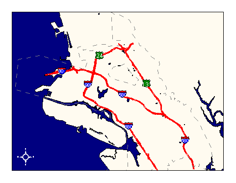
City of Oakland data set: Freeways with on and off ramps |
|
 |
Who maintains the data for this layer: Joan Curtis, OPB Data Maintainer Phone: (510) 238-4777 Who converted the data into a GIS format: Kyle Draganov GIS Technician Phone: unlisted Size of GIS layer (KB): 432 Size of export file (KB): 681 Where is the layer stored (on the k-drive): k:\gisdata\trans\freeway.e00 This GIS layer was last updated on: 10/1/96 This metadata was last updated on: 3/12/97 This layer's FGDC category description is: Transportation |
|
Data Set Description: This layer delineates the centerlines in each direction of the major interstates only. Non-standard Attributes in table:
Data Source History: The freeways were hand selected from the main "streets layer", along with on and off ramps. Only the major interstates were included in this layer; smaller road sized highways, such as Rtes. 185 and 61, were left out. Quality Check: This layer was a sub-set of the street centerline layer, and is as accurate as the streets centerlines. Freeways with 3-dimensional features such as overpasses and tunnels were field-checked from a flashy convertible sportscar by Jonathan Lowe and Kyle Draganov to verify intersections and non-intersections with neighboring streets. The top was down. Security restrictions: No security restrictions. Update Frequency: No scheduled updates--changes to the damaged Cypress freeway are not captured. Update process:
The new Cypress Structure will be updated when accurate coordinates are available. |