|
|
| |||||||||||||||||||||||||||||||||
|
City of Oakland data set: Fire Assessment Districts |
|
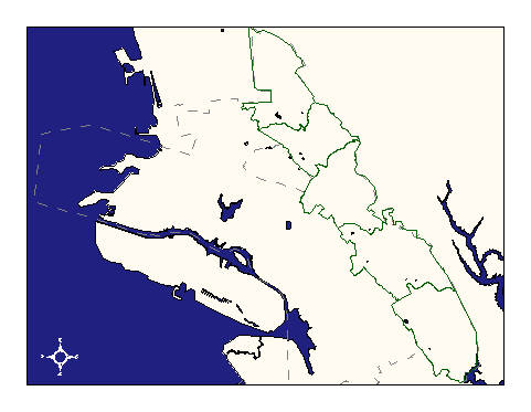 |
Who maintains the data for this layer: Jeff Thompson, OES Data Maintainer Phone: (510) 238-3938 Who converted the data into a GIS format: Kyle Draganov GIS Technician Phone: unlisted Size of GIS layer (KB): 196 Size of export file (KB): 148 Where is the layer stored (on the k-drive): k:\gisdata\gover\firedist.e00 This GIS layer was last updated on: 9/30/96 This metadata was last updated on: 3/20/97 This layer's FGDC category description is: Governmental Units |
|
Data Set Description: Fire assesment districts divide the Oakland Hills into 5 districts for fire-suppression inspection. This layer was snapped to the Street centerlines and City-limit layers for maximum accuracy, and is as accurate as these two layers. Non-standard Attributes in table:
Data Source History: Jeff Thompson supplied OCIS with a "Fire Suppression Assessment District" blueprint style map. Kyle Draganov, Earthwise consulting, translated the boundaries as necessary from street-centerlines and city-limits layers. Accuracy for this layer is as accurate as those used for translation. Kyle's translation involved digitizing from a paper blueprint of 1:21,341 scale. The digitization process included copying selected parts of existing layers (city_lmts and streets) as well as heads-up manual digitizing across areas where the district lines did not follow roadways. Quality Check: No quality checks by non-GIS staff have yet been performed on this layer. Security restrictions: No security restrictions. Update Frequency: When district lines are changed--not planned. Update process:
Update process is not yet defined |